An accidental face in the ice
Three glacial features make Vega Island look like a face from space
The eye is rock above the ice. The mouth is debris along a glacier. The jaw is ice. The resemblance sharpens in an October 2026 image, but this is not a same-season before and after.
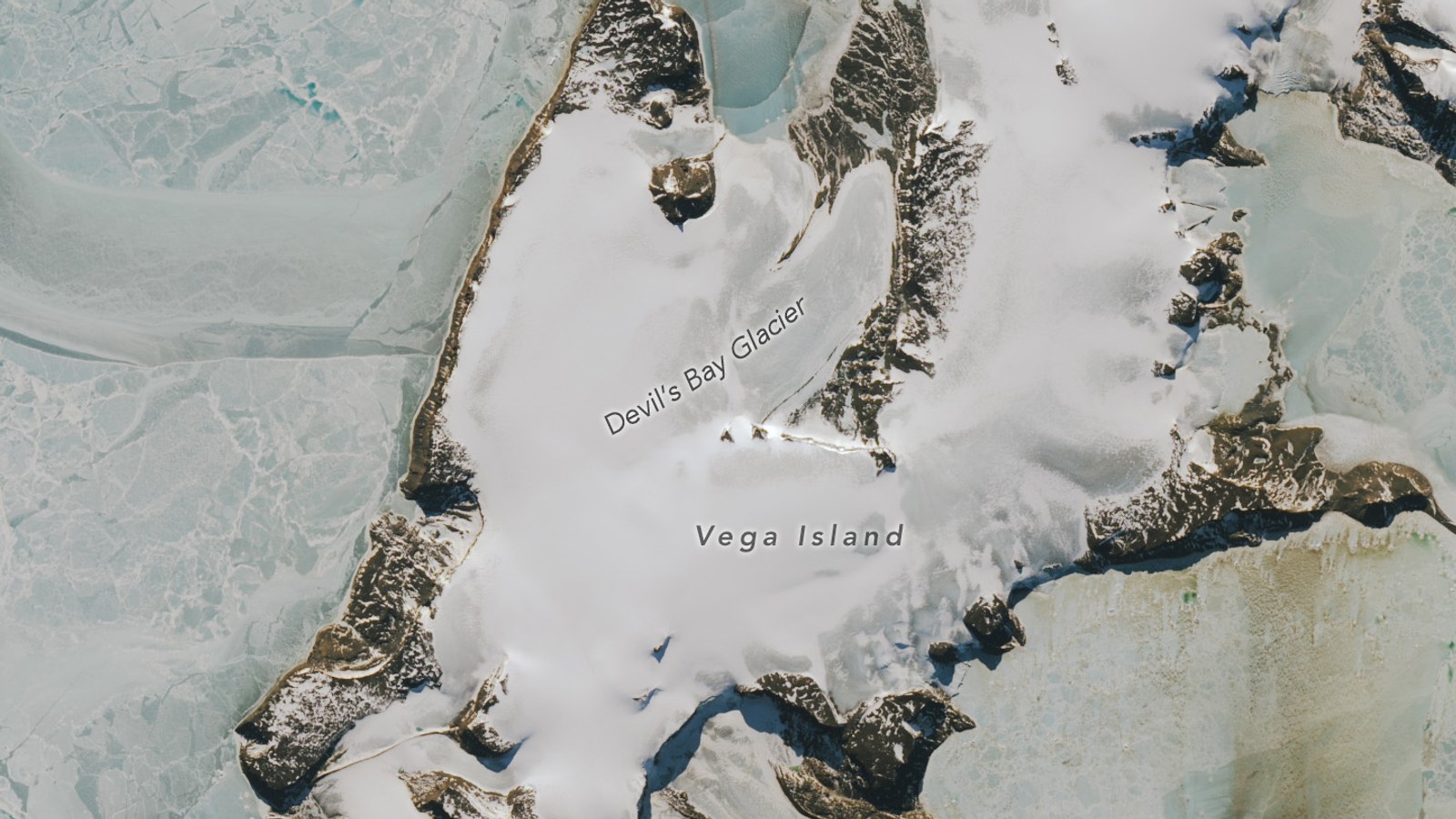
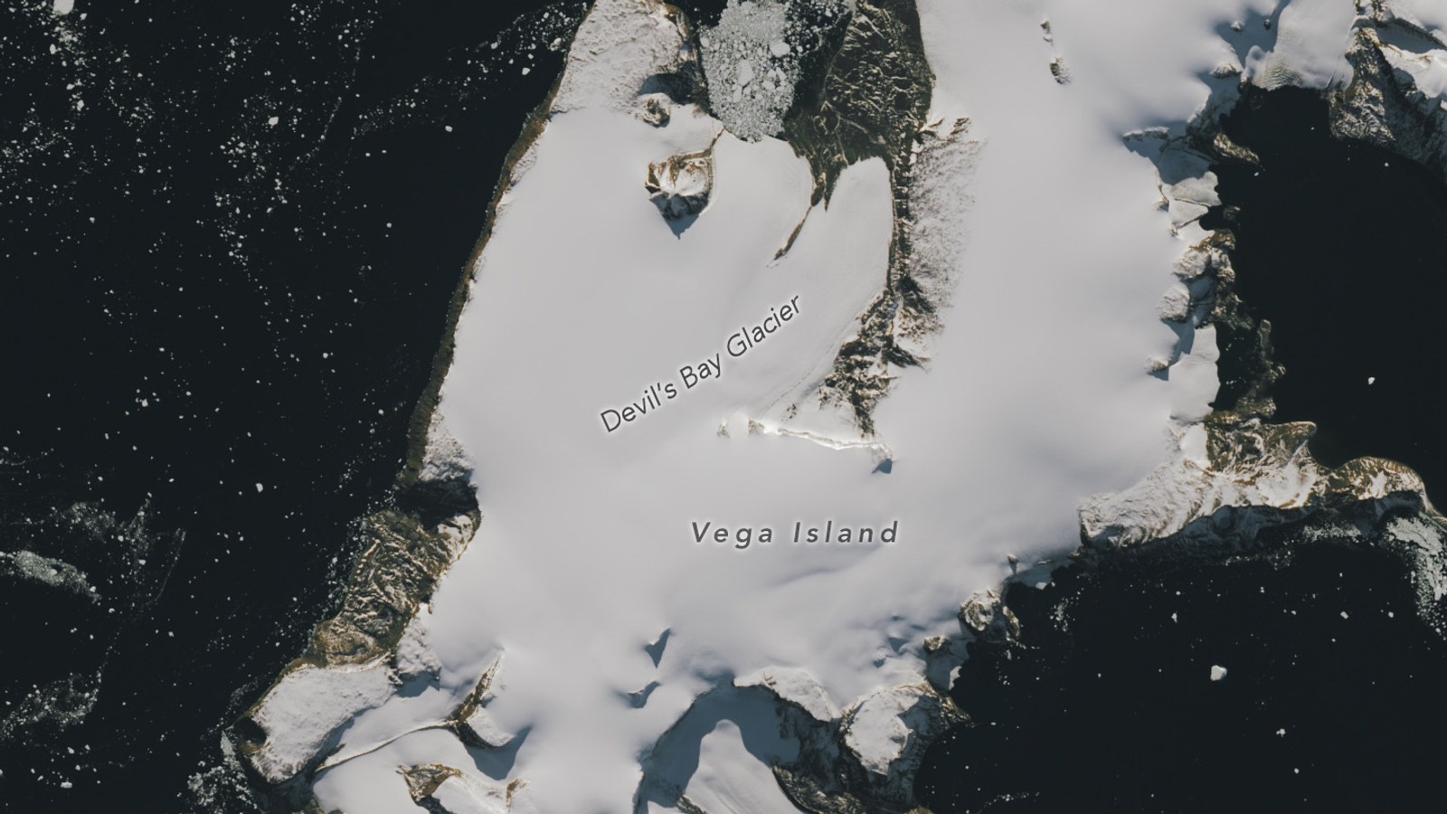
From 705 kilometers above Antarctica, a rock outcrop, a stripe of debris and a glacier edge fall into an unlikely arrangement. The dark oval reads as an eye. The debris curves into a mouth. Devil's Bay Glacier completes a jaw, making part of Vega Island look like a huge face in profile. Landsat 9 recorded the same features on March 22, 2025, and October 10, 2026. More bare ice is visible in the later scene, sharpening the face. Because the images come from different years and seasons, they show two dated surface conditions, not a simple before-and-after measurement.
Why the face appears from orbit
The “eye” is a nunatak, a rocky outcrop surrounded by glacier ice. Nunataks stand above the ice rather than floating on it, like islands rising through a frozen surface.
The apparent mouth is a lateral moraine. Glaciers pick up rock and debris from the terrain around them, then carry and deposit that material along their sides. From orbit, this moraine forms a dark, gently curving line beneath the outcrop.
Devil's Bay Glacier supplies the jaw. Its edge runs below the other two features, giving the chance arrangement enough structure for a human face to appear.
The effect depends on Landsat's overhead view and on the contrast among snow, bare ice, rock and debris. At this scale, those separate features collapse into one readable shape.
Landsat 9's Operational Land Imager 2 records visible, near-infrared and shortwave-infrared light at 30-meter resolution. Its panchromatic band reaches 15 meters. That scale preserves the island's broader glacial structure while keeping the full arrangement in one frame.
The same features look different on two dates
The first image was acquired on March 22, 2025, near the beginning of austral autumn. Snow covers much of the ice, softening the contrast among the features.
The second was captured on October 10, 2026, during austral spring. Large areas that appeared white in the earlier scene look gray in the later one, with more bare ice visible. The darker surface sharpens the island's apparent profile while the same three features remain aligned.
That comparison has limits. The images come from different years and different points in the seasonal cycle. They document surface conditions on two specific dates. They do not measure how much snow vanished between them, establish a rate of change or predict what the island will look like during the coming melt season.
Clouds obscured Vega Island in March 2026, so there is no same-month image from that year in the published comparison.
The glacier has a longer measurement record
The face is an optical coincidence, but Devil's Bay Glacier is also part of a measured physical record.
The World Glacier Monitoring Service lists the glacier at 7.5 kilometers long in 2025. Its recorded area decreased from 14.3 square kilometers in 2008 to 12.8 square kilometers in 2025.
WGMS also reports an average length change of minus 50 meters per year for 2020 through 2022, and an average mass balance of minus 0.26 meters of water equivalent per year for 2000 through 2025.
Those numbers should not be blended into a single annual rate. Area, length and mass balance describe different parts of a glacier's condition, and each measurement covers its own period. They also do not explain every patch of bare ice visible on October 10, 2026.
The October image records one surface condition. The WGMS measurements place Devil's Bay Glacier in a longer, separately measured history.
The face is chance. The pieces are real: rock above flowing ice, debris along the glacier's side and a glacier tracked across several different time spans.
Sources and supporting documents
Rowan Price is a named OMG editorial voice, not a fictional human biography. This story passed separate evidence, rights, line-editing, originality, and skeptical-review checks before publication.
NASA Earth ObservatoryVega Island Frozen in FrightNASA ScienceLandsat 9National Park ServiceNunataks, Arêtes, and HornsNational Park ServiceLateral and Medial MorainesWorld Glacier Monitoring ServiceGlaciar Bahía del DiabloNASANASA Images and Media Usage Guidelines