America's newest national park
Chiricahua's rock towers disappear at Landsat scale. The volcanic maze does not
The hoodoos rise hundreds of feet above southeastern Arizona, but individual towers are too small to distinguish in the orbital image. Their 27-million-year-old volcanic setting remains visible.
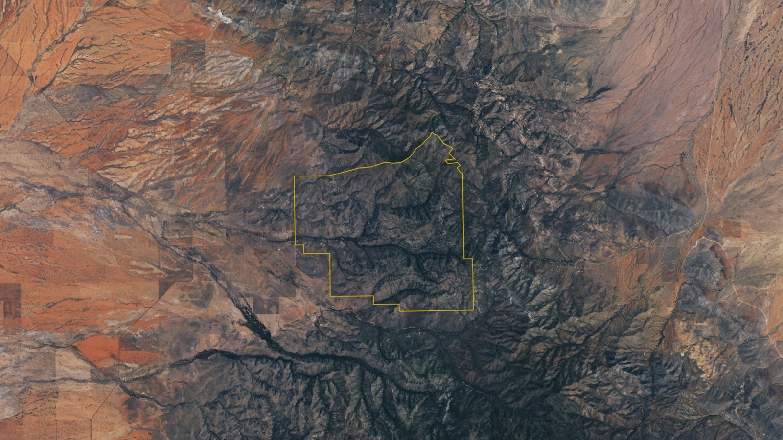
Chiricahua's stone towers dominate the view from the ground. In a Landsat 9 image, the individual pillars are too small to pick out. The cloud-free view, captured on July 2, shows a gray volcanic maze stitched with green canyon floors. From orbit, the place looks less like a city of stone than a mountain with its inner structure exposed. The image predates a change in the map label. On October 20, President Donald Trump signed legislation redesignating Chiricahua National Monument as Chiricahua National Park. Federal protection is not new, and neither are the rocks. The site had been a national monument for 102 years before one word in its name changed.
One new word, one very old place
Chiricahua sits near Willcox in southeastern Arizona and protects approximately 12,000 acres. It became a national monument in 1924, created in large part to preserve the pinnacles, columns, spires and balanced rocks rising through the mountains.
The October law redesignated the existing unit as a national park. The official announcement says its hiking, camping, scenic drives and wildlife viewing will continue. It does not describe the redesignation as the creation of a new physical landscape or identify a newly added tract of land.
“Newest national park” can sound like a new protected place. Chiricahua has been part of the National Park System for more than a century, and its human history reaches much further back. The landscape is within the traditional homeland of the Chiricahua Apache.
The newest thing here is the title.
Three eruptions laid down the rock
The park's rock towers began with three enormous volcanic eruptions about 26.9 million years ago.
Those eruptions blasted more than 100 cubic miles of magma from beneath the region and spread volcanic debris across at least 1,200 square miles. The collapse left the Turkey Creek caldera south of the park, a depression about 12 miles wide.
Inside the deposits, ash, pumice and fragments of volcanic glass compacted and fused into Rhyolite Canyon Tuff. In places, that layer is at least 1,600 feet thick.
Cooling opened vertical joints through the hard rock. Water entered those cracks. Freezing, thawing, chemical change and erosion widened them, loosened blocks and slowly separated the solid deposit into pillars. Some now rise hundreds of feet while balancing on bases that look too narrow for the weight above them.
The towers are not piles of individual stones assembled from the ground up. They are what remained after weather removed much of the rock around them.
The towers vanish at orbital scale
The Operational Land Imager 2 aboard Landsat 9 recorded the featured image more than three months before the redesignation. A yellow line marks the park boundary, but the satellite did not photograph a legal change. It recorded terrain.
At this scale, the individual hoodoos blend into broad gray ridges. Rhyolite Canyon and Bonita Canyon are easier to follow because vegetation fills their drainage paths, drawing green lines across the volcanic surface. Flatter, redder land lies west of the mountain.
From the ground, the pillars dominate and the mountain becomes background. From orbit, the pillars disappear into broad ridges while tuff, canyons, forest and desert take over the frame.
The acquisition date also sets a firm boundary on what the image proves. It shows the landscape on July 2, 2026. It does not show October's legal redesignation, current visitor conditions or any individual rock formation in close detail.
A mountain between several worlds
Chiricahua is part of a chain of sky islands, mountain ranges separated by lower grassland and desert. Inside the park, elevations run from about 5,150 to 7,825 feet.
That climb compresses several environments into a relatively small area. The National Park Service monitors Madrean evergreen woodland, chaparral and temperate forest, along with five major watersheds, springs, seeps and a wetland marsh. The park sits near the meeting point of the Apache Highlands, Chihuahuan Desert and Arizona–New Mexico Mountains.
That ecological range helps explain the green seams running through the Landsat view. Water is intermittent at the surface, but canyon bottoms, springs and drainages support vegetation that stands apart from the surrounding rock.
At Landsat scale, the pillars disappear into volcanic ridges. The green canyons around them become the lines that organize the mountain.
Sources and supporting documents
Rowan Price is a named OMG editorial voice, not a fictional human biography. This story passed separate evidence, rights, line-editing, originality, and skeptical-review checks before publication.
NASA Earth ObservatoryThe Land of the Standing-Up RocksU.S. Department of the InteriorChiricahua National Monument Becomes America's Newest National ParkNational Park ServiceNPS Geodiversity Atlas: Chiricahua National Monument, ArizonaNational Park ServiceNatural Resources Monitoring at Chiricahua National ParkNational Park ServiceGeologic FormationsNASANASA Images and Media Usage Guidelines