Three years in the Weddell Sea
A-81 reached South Georgia, 2,300 kilometers north-northwest of Brunt. Then it slowed
The iceberg spent more than three years in the Weddell Sea before moving north. Its slowdown near the island does not confirm that it grounded.
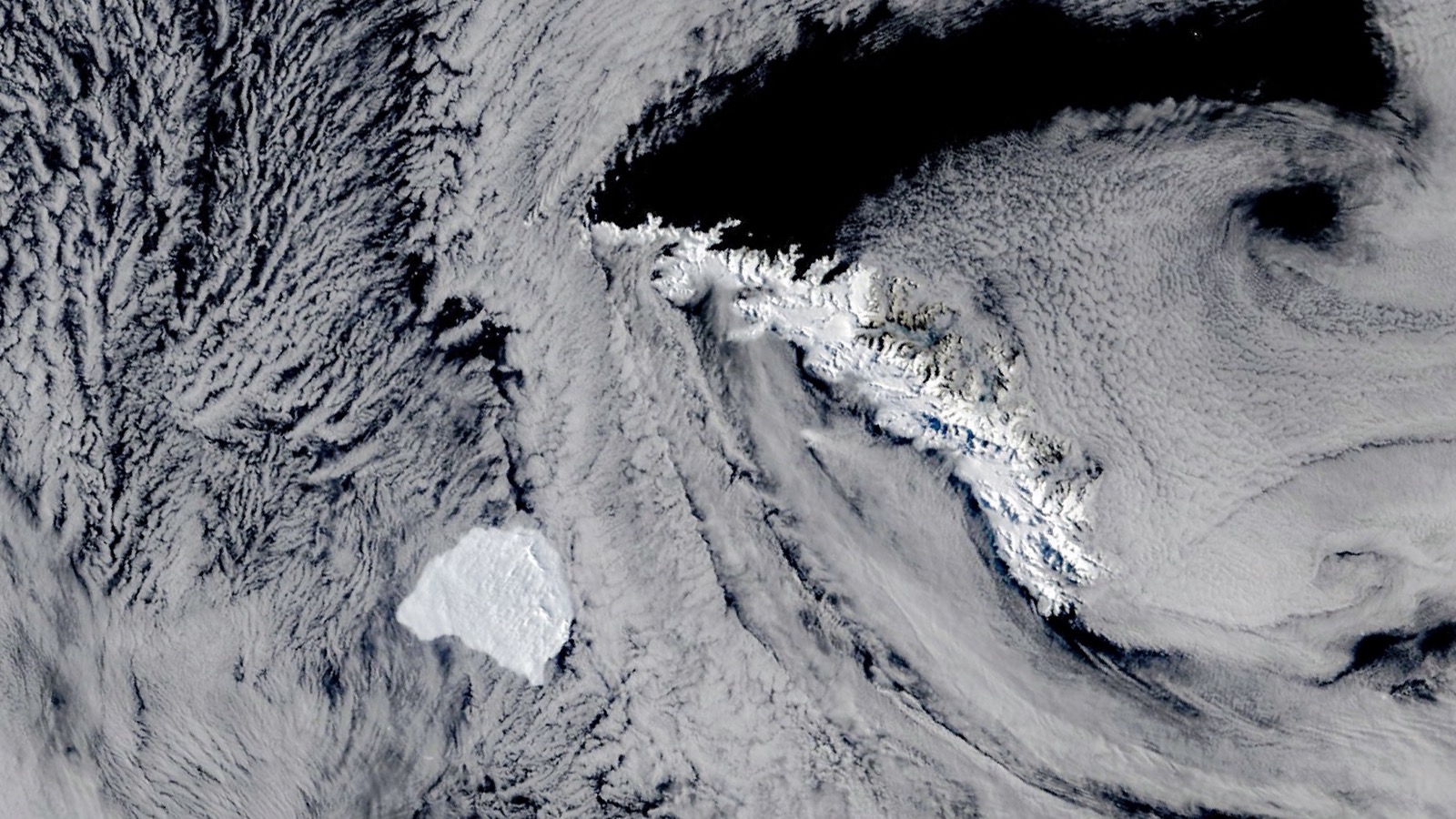
In the October 20 satellite image, South Georgia is a long white-backed island and A-81 is a blunt block just off its southwestern end. The iceberg spent more than three years moving through the Weddell Sea. After reaching the tip of the Antarctic Peninsula in May, it traveled north into the Scotia Sea and arrived beside the island within months. By the time NASA’s Terra satellite saw it, its drift had slowed.
The latest file puts it at 28 by 25 nautical miles
The U.S. National Ice Center’s October 22 tracking file placed A-81 at 54.9 degrees south and 38.33 degrees west. Analysts listed it as 28 nautical miles long and 25 nautical miles wide, with an estimated area of 1,341.79 square kilometers.
That is a weekly tracking estimate, not a perfect rectangle or a survey made from the ice. USNIC analysts use visible, infrared and synthetic-aperture radar satellite imagery to locate and measure Antarctic icebergs.
The letter A records where the iceberg was first sighted: the Antarctic quadrant spanning 0 to 90 degrees west, which includes the Weddell Sea. The number marks its place in the center’s naming sequence.
British Antarctic Survey estimated A-81 at roughly 1,550 square kilometers when it broke free in 2023. The two area figures should not be treated as a precise measurement of melting. They come from different dates and may also reflect differences in image outlines and measurement.
Its route turned north after May
A-81 calved from the Brunt Ice Shelf in January 2023, then spent more than three years inside the Weddell Sea. NASA says the clockwise-flowing Weddell Gyre carried it along the Antarctic coast.
By May 2026, the iceberg had reached the tip of the Antarctic Peninsula. It then moved north into the Scotia Sea. In late October it was beside South Georgia, roughly 2,300 kilometers north-northwest of the Brunt Ice Shelf. That figure is the displacement between the two locations, not the distance A-81 traveled along its route.
NASA says the berg’s progress slowed noticeably in the days before the October 20 image. Jan Lieser of Australia’s Bureau of Meteorology and retired University of Maryland scientist Christopher Shuman interpreted the movement as A-81 apparently bumping along the edge of South Georgia’s shallow underwater shelf.
Apparently matters. The satellite image shows the iceberg and island from above. It does not show contact with the seafloor, and the cited official records do not declare A-81 grounded.
The crack waited decades before finishing the job
A-81 formed along Chasm 1, a major fracture in the Brunt Ice Shelf. The rift remained relatively stable for roughly 35 years, then began growing again around 2012.
British Antarctic Survey says the crack finally crossed the shelf on January 22, 2023. The break occurred between 19:00 and 20:00 UTC and released a block of ice initially estimated at 1,550 square kilometers.
Halley VI Research Station sits on the remaining Brunt Ice Shelf. BAS had moved the station 23 kilometers to a safer location during the 2016 to 2017 Antarctic summer. At the time A-81 calved, the organization said the station area remained unaffected.
BAS described the break as part of the ice shelf’s natural calving cycle and said it had no evidence climate change played a significant role in this event. That assessment applies to A-81’s formation, not to every Antarctic iceberg or ice shelf.
One image fixes the position, not the outcome
The MODIS instrument on Terra captured A-81 southwest of South Georgia on October 20. Thin clouds partly obscure the scene, but the iceberg’s blocky outline and the island’s long spine remain visible.
The image contains no map of the seabed and no forecast. The October 22 USNIC file supplies a later position and size estimate, but it does not report a velocity, grounding determination or future track.
As of that file, A-81 was centered at 54.9 degrees south and 38.33 degrees west. What happens next is not visible in the image. The official record stops with a large iceberg beside an island shelf, moving more slowly than it had days earlier.
Sources and supporting documents
Rowan Price is a named OMG editorial voice, not a fictional human biography. This story passed separate evidence, rights, line-editing, originality, and skeptical-review checks before publication.
NASA Earth ObservatoryA-81 Reaches South GeorgiaU.S. National Ice CenterAntarctic Iceberg Data and October 22, 2026 CSVU.S. National Ice CenterAntarctic Iceberg Naming and Tracking InformationBritish Antarctic SurveyBrunt Ice Shelf in Antarctica calves giant icebergBritish Antarctic SurveyGlaciological monitoring of Brunt Ice ShelfNASANASA Images and Media Usage Guidelines