Straight lines inside a wetland
A northern Manitoba farm grid changed color in 81 days. The wetlands kept their curves
More than 100,000 acres are actively farmed in the Carrot River Valley. The images show a seasonal change, not what every 2026 field grew or whether each one had been harvested.
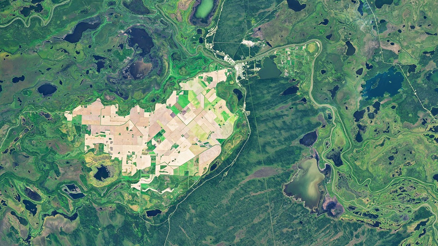
On July 2, northern Manitoba looked as though someone had laid graph paper across a wetland. Rectangular fields filled the center of the Landsat image. Around them, rivers looped, lakes interrupted the forest, and narrow channels curled through marshes. Field boundaries held straight lines while channels, lakeshores and wetland edges bent around them. Eighty-one days later, Landsat returned to the Carrot River Valley. Many fields that appeared green in July were brown by September 21. The pair records the landscape moving from summer growth toward harvest season. It does not show what happened in every field.
More than 100,000 acres fit inside the grid
The Carrot River Valley lies west of The Pas between the Carrot and Pasquia rivers. NASA describes more than 40,000 hectares, or 100,000 acres, as actively farmed.
The Rural Municipality of Kelsey uses two related figures. It lists about 178,040 acres as farmable and 110,000 acres as currently farmed. The categories are different, so the larger number should not be presented as another estimate of active production.
The municipality identifies the valley as Manitoba's most northerly agricultural area. Around it lie the lakes, bogs, marshes, forests and waterways of the Saskatchewan River Delta, which an official watershed plan describes as one of North America's largest freshwater deltas.
From orbit, the cultivated land reads as a compact geometric pocket inside a landscape organized by water.
Long daylight helps, but wet ground can steal time
The valley lies north of the 53rd parallel. The municipality and watershed plan credit its longer summer daylight with about 10 additional growing days compared with southern Manitoba.
The extra light does not remove the complications of farming this far north. NASA reported that wet conditions delayed planting in the area compared with places farther south in Manitoba's Northwest crop-reporting region.
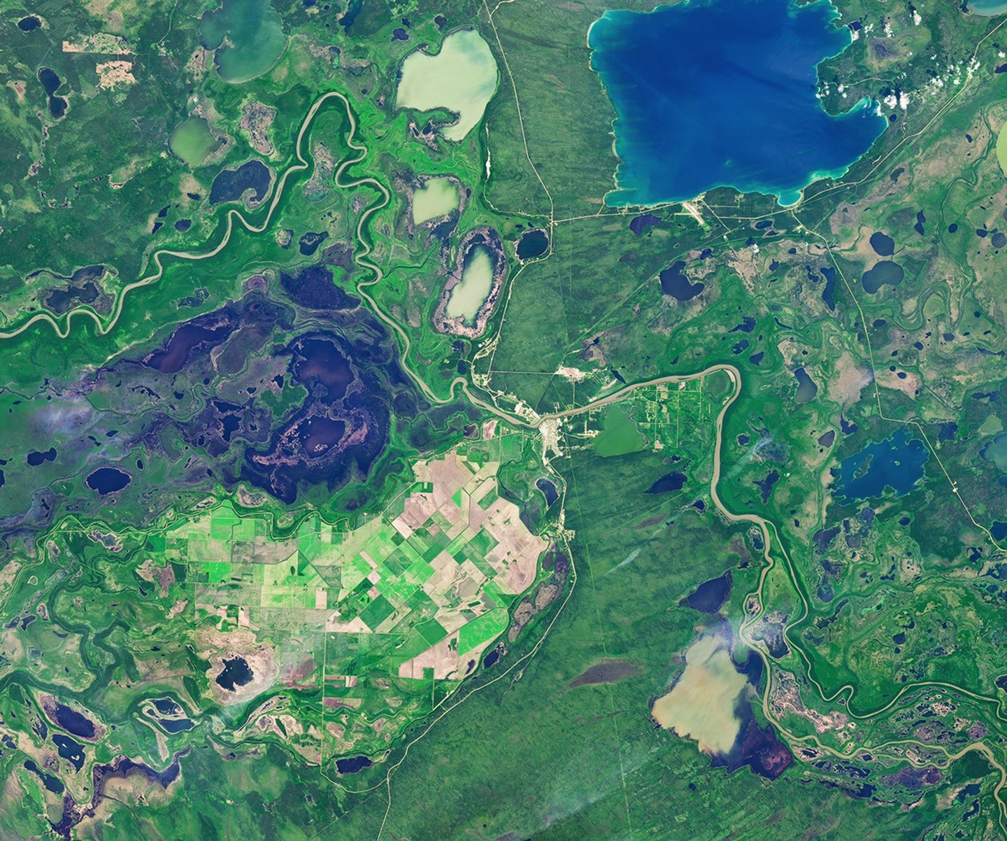
By July 2, Landsat 9 showed green vegetation across many fields. On September 21, Landsat 8 recorded a paler grid, with many fields brown and less water visible in parts of the surrounding wetlands.
Both satellites used versions of the Operational Land Imager. The July scene came from Landsat 9 and the September scene from Landsat 8.
Farming depends on moving water
The watershed plan describes this country as very flat. With little natural slope, drainage is difficult, and low ground can flood.
Agriculture therefore depends on a modified surface-water system using dikes and pumps for flood protection. NASA traces a major local flood-control and drainage project to the 1950s.
That infrastructure helps sustain the agricultural grid, but it has not erased the landscape around it. Straight field boundaries meet curving channels, irregular shorelines and marshes that remain visibly shaped by water.
The contrast looks almost diagrammed from orbit. One pattern records surveyed land. The other follows the delta.
Brown is not the same as harvested
Many fields appear brown in the September image. The color change alone cannot prove that every one had been harvested. A satellite image by itself cannot separate harvesting from crop maturity, drying vegetation and every other cause of a field's changing appearance.
The available crop records have two additional limits.
Agriculture and Agri-Food Canada had not released its 2026 crop inventory by late September. Its 2025 inventory showed that canola and spring wheat dominated the valley that year, with smaller patches of Canary seed. Those earlier crop labels cannot be assigned to individual fields in the 2026 images.
Manitoba's September 22 crop report said spring wheat harvest was about 50 percent complete across the entire Northwest region. Canola harvest was about 10 percent complete. The report also said precipitation and standing water in low areas had delayed work.
Those percentages cover the Northwest reporting region. They are not harvest results for the Carrot River Valley or for any rectangle visible in the Landsat scene.
What the two images can show is visible at a glance. Over 81 days, much of the field grid faded from green toward brown. The rivers, lakes and marsh channels kept bending around it.
Sources and supporting documents
Rowan Price is a named OMG editorial voice, not a fictional human biography. This story passed separate evidence, rights, line-editing, originality, and skeptical-review checks before publication.
NASA Earth ObservatoryAn Agricultural “Island” in the Saskatchewan River DeltaRural Municipality of KelseyElected Officials & General InformationGovernment of Manitoba and Kelsey Conservation DistrictCarrot-Saskatchewan River Integrated Watershed Management PlanManitoba AgricultureManitoba Crop Report, September 22, 2026NASANASA Images and Media Usage Guidelines